ePrivacy and GPDR Cookie Consent management by TermsFeed Privacy Policy and Consent Generator PR TF 25 Las Raíces - Lomo de La Jara

PR TF 25 Las Raíces - Lomo de La Jara

PR-TF 25

Las Lagunetas

Incident Incident

Route partially closed - Works

Trabajos de conservación de pistas forestales

Route temporarily closed - Warnings (fire, wind, etc.)

Itinerario cerrado debido al incendio forestal del verano de 2023. Abierto desde el cruce con la TF 24 hasta casa Don Leandro.

Route temporarily closed - Warnings (fire, wind, etc.)

Itinerario cerrado debido al incendio forestal del verano de 2023. Abierto desde el cruce con la TF 24 hasta casa Don Leandro.

Route temporarily closed - Warnings (fire, wind, etc.)

Itinerario cerrado debido al incendio forestal del verano de 2023. Abierto desde el cruce con la TF 24 hasta casa Don Leandro.

Route temporarily closed - Warnings (fire, wind, etc.)

Itinerario cerrado debido al incendio forestal del verano de 2023. Abierto desde el cruce con la TF 24 hasta casa Don Leandro.

Las Raíces - Lomo La Jara

Difficulty: Medium

Description

This trail immerses walkers in the Las Lagunetas Protected Landscape as it runs from the Las Raíces Recreational Area to the forest of Agua García. 

The route begins by skirting the Madre del Agua ravine through a Canary Island pine forest before crossing the El Bailadero track that leads to the Madre del Agua water gallery, which is now walled up. 

The path then leads to Lomo Arrastradero along a path reinforced with wooden steps and takes you onto Camino del Centeno until you reach Camino Paso del Muerto on your left. 
From here, continue to the Las Pasadillas ravine and climb some stone steps to the top. 

Follow the path to the La Herradura track and then on to Cruz de Fune. Shortly afterwards you will reach the Las Calderetas Recreational Area. Follow the signs to Lomo La Jara to finish the trail in the forest of Agua García, a magnificent enclave of laurisilva forest in the north of the island.

Tips

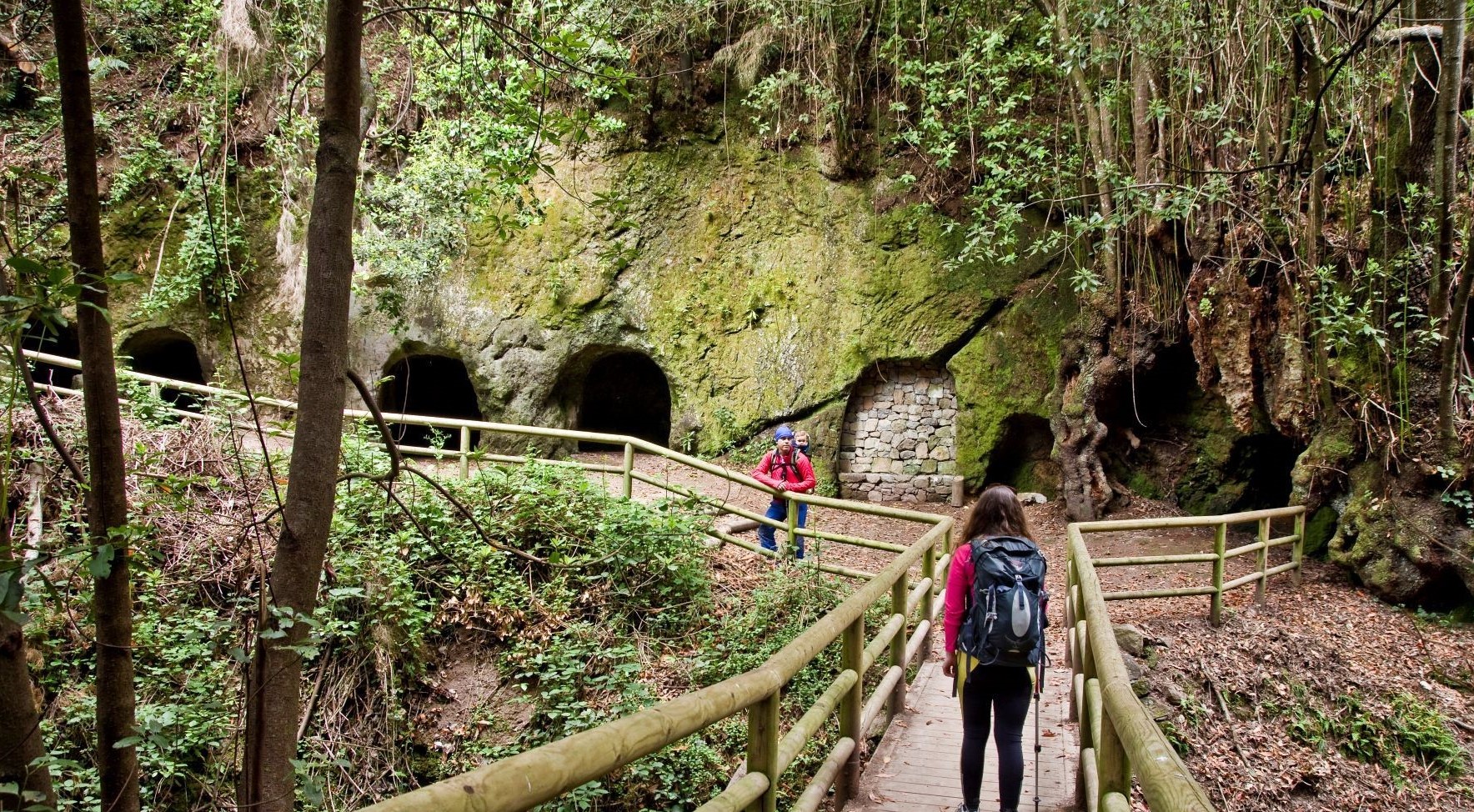
  • Always stay on the marked trail and do not enter private property, hunting grounds, water galleries, wells or caves.
  • Pay special attention when crossing or walking along trails used by bicycles, horses or motor vehicles and when walking in ravines with water courses.
  • Avoid direct encounters with potentially dangerous animals, such as livestock, beehives, and dogs.
  • Proceed with caution and watch for obstacles, loose rocks, uneven terrain or steep slopes to avoid accidents and falls.
  • Check out our guide to hiking in Tenerife and, if necessary, contact the emergency services by calling 112.


Recommendations and tips

Guides

No data available

Permits

  • [TEMPORARY MEASURE] Free access without authorisation or reservation for natural or legal entities of a public or private nature, both non-profit (town councils, schools, associations, clubs, etc.) and for-profit (active tourism companies), until 31 December 2024 as established in the Resolution.
  • Free access for all other visitors, no reservation required.
  • Email for enquiries - This email address is being protected from spambots. You need JavaScript enabled to view it.
More information

Technical information sheet

Route information

Walking route

Tenerife ON

Linear

10,57 km

4 h 5 m

648,20 m

719,87 m

One way with fitness level 3/5

  • Altitude gain:648,20 m

  • Altitude loss:719,87 m

  • Maximum altitude:1.416,12 m

  • Minimum altitude:898,58 m

Signage

Route code

PR-TF 25

Posts and signs displaying the PR code and yellow and white marks.

Signage

Route map and profile

Elevation profile

Difficulty

Medium *MIDE safe mountain criteria

  • Maximum altitude:1.416,12 m

  • Minimum altitude:898,58 m

Connections with other routes

  • /
  • /
  • /
  • /
  • /
  • /

How to get to route start point

Las Raíces Recreational Area, El Rosario.

Bus stop 800 m from Las Raíces Recreational Area in La Esperanza (Transportes La Esperanza, 922 548 080).

Parking spaces in the recreational area.

How to get to route end point

Lomo La Jara Recreational Area, Fuente Fría track, from calle Carril de Millete.

No service in the surrounding area.

Parking spaces in the recreational area, with difficult access by forest track.

Municipalities passed through

  • Candelaria
  • El Rosario
  • El Sauzal
  • La Matanza de Acentejo
  • Tacoronte

Protected Areas

Transit

Paisaje Protegido de Las Lagunetas

The Las Lagunetas Protected Landscape is situated on the north side of the Pedro Gil ridge, in the north-east of Tenerife.  This ridge was formed over the course of numerous phases of eruption less ...

Discover the Protected Area
Paisaje Protegido de Las Lagunetas

Weather

Today, monday, in El Sauzal


Clouds
Wind

8 km/h

Temperature

19ºC Maximum

17ºC Minimum

Rain

12%

3 day forecast

tuesday

20ºC Maximum

18ºC Minimum

wednesday

20ºC Maximum

18ºC Minimum

thursday

21ºC Maximum

19ºC Minimum

Places of interest

These are some of the points of interest you can find along this route.

Barranco_Toledo
Ravine

Barranco de Toledo

Small ravine in the laurel forest of Agua García featuring the famous caves from which trachyte...

Vinatigos_Centenarios
Monumental tree

Centennial Viñatigos

Two specimens of viñatigo (Persea indica) surrounded by suckers in the form of a cage....