ePrivacy and GPDR Cookie Consent management by TermsFeed Privacy Policy and Consent Generator VM 20. Pista de Arenas Negras y Pista de Montaña Cascajo

VM 20. Pista de Arenas Negras y Pista de Montaña Cascajo

VM-20

20.- Pista de Arenas Negras y Pista de Montaña Cascajo

Description

This route climbs through a Canary Island pine forest with undergrowth of faya (Morella faya) and tree heath (Erica arborea), where you will be able to admire the large, majestic pines. 

Some of these specimens, such as the Las Tres Pernadas pine, are classified as monumental. Amidst the trees you will also be able to spot a multitude of birds, such as blue chaffinches, blue tits and woodpeckers.

As you advance, you will notice that the humidity decreases as you climb higher. This leads to other species growing alongside the pine trees, such as tagasaste (Cytisus proliferus), codeso (Adenocarpus foliolosus) and jara (Cistus symphytifolius). 

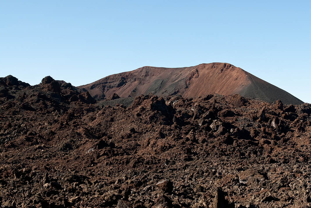
Further on, the landscape changes again as you enter areas of recent volcanic activity. This gave rise to new landscapes that are now populated with Canary Island pines and other colonising species that transform the most inhospitable volcanic terrain into woodland amidst the lava. 

Pay special attention when crossing the slopes of Montaña de Los Poleos and Montaña de La Cruz, where you will be rewarded with an exceptionally beautiful panoramic view of this landscape with the peak of Mount Teide in the background.

Tips

  • Always stay on the marked trail observing all traffic rules established in the regulations. 
  • When parking, keep away from water intakes or firefighting water storage tanks, and do not block the passage of other vehicles or access to the track.
  • Be extra careful both at junctions with paths and tracks and on sections shared by walkers, horse riders and cyclists. 
  • Proceed with care to avoid accidents that may be caused by obstacles, landslides and uneven terrain. 
  • Check our guide to motor vehicle routes and, if necessary, contact the emergency services by calling 112.
Recommendations and tips

Guides

No data available

Permits

Prior authorisation through the Reservation Centre of the Tenerife Island Council is compulsory for the following vehicles:

  • Trials, enduro and motocross bikes.
  • ATVs and quads with a handlebar steering system.
  • Off-road vehicles with tyres of 10 to 15mm tread depth.
  • Power-assisted pedal cycles with a power output of more than 0.5 kW, to supplement the muscle power of the rider.
  • Caravan of up to six motor vehicles in motion with a maximum distance of 30 metres separating them.

Check the Regulations for information on prohibited vehicles.

No reservations are required for other vehicles, provided that they meet the recreational use requirements for this network of trails.

More information

Technical information sheet

Route information

Motor vehicle route

Tenerife ON

Linear

14,20 km

1 h 0 m

811,77 m

236,42 m

At an average speed of 15 km/h

  • Altitude gain:811,77 m

  • Altitude loss:236,42 m

  • Maximum altitude:1.678,68 m

  • Minimum altitude:1.043,90 m

Signage

Route code

VM-20

Tracks for motor vehicles are marked with blue signs and posts that include:

  • Direction.
  • Route number.
  • Distance to end point.
Signage

Route map and profile

Elevation profile

  • Maximum altitude:1.678,68 m

  • Minimum altitude:1.043,90 m

Connections with other routes

How to get to route end point

Km 12 on the TF-38 Boca Tauce - Chío road.

Municipalities passed through

  • El Tanque
  • Garachico
  • Guía de Isora
  • Santiago del Teide

Protected Areas

Transit

Parque Natural de la Corona Forestal

The Corona Forestal is the largest protected natural area in the Canary Islands, one of the most extensive forests on the islands, the lungs of Tenerife and the gateway to Mount Teide.  As its name ...

Discover the Protected Area
Parque Natural de Corona Forestal

Transit

Reserva Natural Especial del Chinyero

The Chinyero Special Nature Reserve is located on the Abeque ridge, one of the three volcanic rifts on the island and the most active at present. Two historical eruptions have taken place here: ...

Discover the Protected Area
Reserva Natural Especial del Chinyero

Weather

Today, monday, in Garachico


Clouds
Wind

6 km/h

Temperature

21ºC Maximum

16ºC Minimum

Rain

0%

3 day forecast

tuesday

21ºC Maximum

16ºC Minimum

wednesday

22ºC Maximum

18ºC Minimum

thursday

22ºC Maximum

18ºC Minimum

Places of interest

These are some of the points of interest you can find along this route.

Pino_Tres_Pernadas
Monumental tree

Los Tres Pinos / Pino de las Tres Pernadas

Pine tree that splits into three large trunks 60 centimetres above the ground. Surrounded by an...