Full information about the 2025 mouflon control campaign
Temporary restrictions on access to areas of natural beauty for safety reasons
The mouflon (Ovis gmelini) is an invasive species introduced to the summits of Tenerife in the 1970s for hunting purposes.
Although initially only found in Teide National Park, its range has now expanded to lower altitudes, affecting other protected natural areas such as Corona Forestal Natural Park, Chinyero Special Nature Reserve, Las Lagunetas Protected Landscape and Siete Lomas Protected Landscape.
This herbivore poses a threat to the conservation of native, endemic and endangered plant species. For this reason, control campaigns are carried out to cull a certain number of specimens each year using firearms.
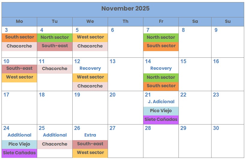
Precisely, and with the aim of ensuring the safety of people on the specific dates in each of the seven zones into which the action area has been divided (called sectors: Southeast, West, North, South, Pico Viejo, Siete Cañadas, and Chacorche), recreational transit — both off-trail and along paths and tracks — is prohibited within the control area during the following times:
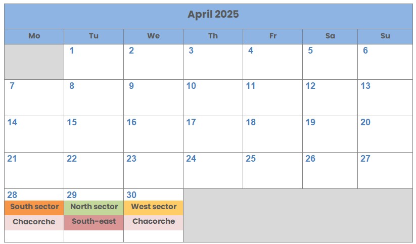
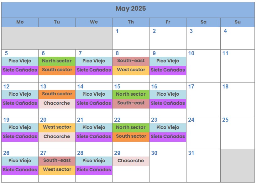
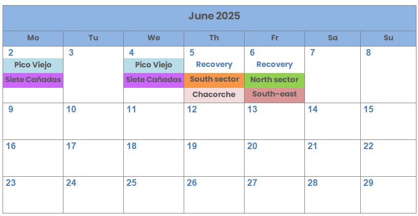
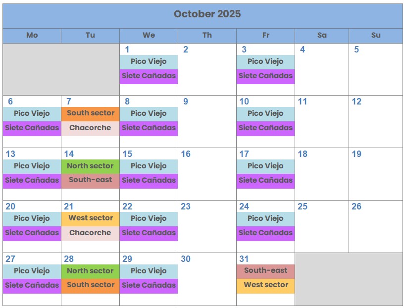
- Chacorche Sector: from 07:00 to 16:00.
- Southeast Sector: from 07:00 to 16:00.
- West Sector: from 07:00 to 16:00.
- North Sector: from 07:00 to 16:00.
- South Sector: from 07:00 to 16:00.
- Siete Cañadas Sector: from 07:00 to 14:00.
-
Pico Viejo Sector: from 07:00 to 17:00.
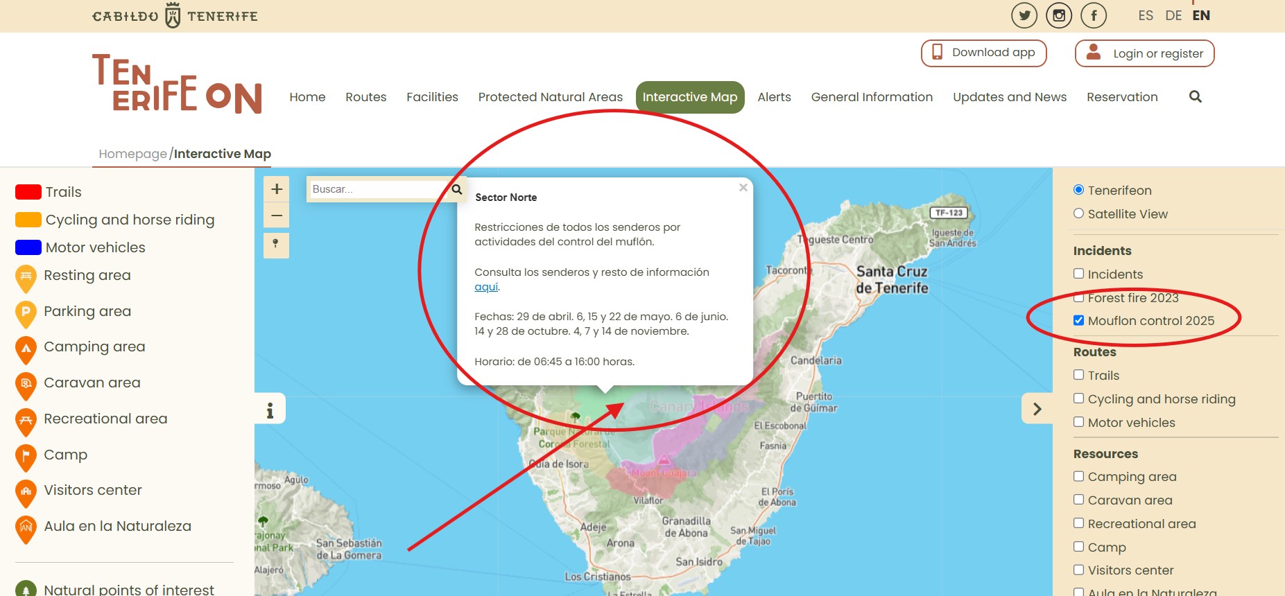
If you intend to pursue any outdoor activity during the months of April, May, June, October or November 2025, we recommend that you consult the interactive map (activate the Mouflon Control 2025 layer) and click on the coloured areas to see which days and routes or sections of routes will be closed as a result of the mouflon control campaign.
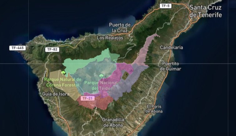
These are the seven sectors affected by the 2025 mouflon control campaign:
Below is a schedule of the dates and sectors affected:
The following text lists the routes that are closed in each sector, either totally or partially:
Chacorche Sector (pink on the map).
- PR TF 35.4.- Camino a Candelaria (Aguamansa – La Crucita section).
- PNT 17 Igueque.
- PNT 21 Corral del Niño – Yegua Blanca.
Southeast Sector (lilac on the map).
- PR TF 86 El Contador Recreational Area - Parador Nacional.
PR TF 86.1 Ramal a la Casa Forestal. - PR TF 86.2 Ramal Zona de Acampada Fuente del Llano.
- BC 4 Pinares del Sur and Volcanes Negros.
- VM 9 Pista General de Arico.
- VM 10 Pista El Palmero.
West Sector (light orange on the map).
- PR TF 69.1 Chiguergue – Chasogo.
- PR TF 70 Guía – Tágara – Boca Tauce.
- PR TF 70.1 Tágara – El Jaral.
- PR TF 70.2 Llano del Negro – Las Fuentes.
- PR TF 70.3 Chavao.
- PR TF 70.5 Trail connecting PR TF 70 with PR TF 70.3.
- PR TF 70.6 Trail connecting PR TF 70.1 with PR TF 70.2.
- PR TF 86 Villa de Arico – Cumbre de Arico.
- PR TF 86.2 Arico Nuevo – El Contador Recreational Area.
- SL TF 60 Santiago del Teide – Arguayo.
- SL TF 201 Chío – Arguayo.
- SL TF 203 Chío – Los Arenales.
- BC 3 Pinar de Chío.
- BC 4 Pinares del Sur and Volcanes Negros.
North Sector (green on the map) and South Sector (brick red on the map).
- GR 131 Anaga – Chasna. Vilaflor to Degollada de Guajara section.
- PR TF 41 Playa del Socorro – Pico Teide (Route 040).
- PR TF 43 Garachico – Chinyero.
- PR TF 43.1 San José de los Llanos – Montaña Chinyero.
- PR TF 43.2 Los Partidos – Chinyero.
- PR TF 43.3 Santiago del Teide – Montaña Chinyero.
- PR TF 71 Adeje – Las Lajas Recreational Area.
- PR TF 72 Vilaflor – Lunar Landscape – Vilaflor.
- PR TF 83 Altos de Granadilla.
- PR TF 83.1 Las Vegas – Los Escurriales.
- BC 1 Northern Forest Route.
- BC 5 Pinares de Vilaflor.
- VM 12 Pista Chanajiga - Fuente Los Corchos.
- VM 13 Pista La Bermeja and Pista Almagre and Cabezón.
- VM 15 Pista de Lolita and Pista Caño Chingue.
- VM 17 Pista del P.K. 29 (Track at km 29), Pista de las Vistas de Sánchez, Pista Barranco de la Arena and Pista El Lagar.
- VM 20 Pista de Arenas Negras, Pista Montaña Las Flores and Pista de Montaña Cascajo.
- VM 21 Pista Madre del Agua.
Siete Cañadas Sector (purple on the map).
All trails in this sector will be closed, except for the following, which will remain open:
- PNT 19 Majúa.
- VM 09 Pista General de Arico.
- Roads and roadside viewpoints.
The following areas are also open:
- Moderate use zone between PNT 19 (Montaña Majúa trail) and the TF-21 road.
- Parador Nacional – Cañada Blanca Visitor Centre – La Ruleta special use zone.
- El Portillo special use zone.
- Minas de San José.
- Roads and roadside viewpoints.
- El Portillo drinking water supply systems and access from the old administrative offices.
Pico Viejo Sector (blue on the map).
All trails in this sector will be closed, except for the following, which will remain open:
- PNT 01 La Fortaleza, section between El Portillo and the PNT 24 Portillo Alto trail.
- PNT 03 Roques de García, anticlockwise section between La Ruleta and the PNT 23 Los Regatones Negros trail.
- PNT 07 Montaña Blanca – Pico Teide.
- PNT 10 Telesforo Bravo.
- PNT 11 La Fortaleza Viewpoint.
- PNT 12 Pico Viejo Viewpoint.
- PNT 18 Chavao.
- PNT 24 Portillo Alto, section from the trailhead to PNT 01 La Fortaleza trail.
- PNT 40 Llano de Ucanca – Boca Tauce.
- Roads and roadside viewpoint.
The following areas are also open:
- Moderate use zone between trails PNT 01 La Fortaleza, PNT 24 Portillo Alto and the TF-21 road.
- El Portillo special use zone.
- La Ruleta – Roques de García special use zone.
- Juan Évora special use zone.
- Cable car base station and accesses.
- Cable car upper station and La Rambleta area.
- Minas de San José.
It is important to bear this information in mind when planning your visits to the area. If you have any queries, you can contact the Cabildo de Tenerife citizen helpline on 922 23959500 // 901 501901 or via the form on the website https://sede.tenerife.es/es/contacto.
You can consult the ANNOUNCEMENT regarding the authorization for mouflon population control in Tenerife on this link.